

Archaeology
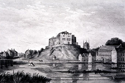
Castle Mill
Thanks to two community archaeological digs which took place in October 2022 and March 2023, we have uncovered some fascinating historical finds on the area near to Holloway in the Castle Grounds. The site is known to have housed an historical mill potentially dating back to the Medieval period.
The dig project, ‘Revealing Castle Mill’, took place thanks to funding from the UK Government through the UK Shared Prosperity Fund, and was led by archaeologist William Mitchell, a lecturer in Archaeology at Staffordshire University.
Archaeologists were looking for the survival of any key historical remains that could shed further light upon the early development of Tamworth and the mill.
These free events were open to the public to view and help with the checking process, plus school groups were able to book a visit too. The team were overwhelmed by the enthusiastic response from hundreds of members of the public and were joined every day by crowds of adults and children, all keen to help uncover the hidden history beneath our feet.
Amongst the exciting finds the foundations of the castle mill were again revealed, exposing evidence of where the wheel would have been. Other items uncovered included a wide range of glass, ceramics, animal bones, buttons and a knife. These will be cleaned and fully documented by Staffordshire University students.
William Mitchell, Lead Archaeologist said:” Our second dig revealing the Tamworth Mill has been very successful and well received by all. We had an overwhelming turn out from the public, plus six school classes assisted in the digging.
“Excitingly, the well-preserved remains of the 18th century water-wheel pit was exposed, confirming that there is excellent survival of the mill foundations. Above this we recovered lots of Edwardian artefacts, thrown in after the mill was demolished. This dig has again shown the potential for this type of archaeological project in bringing varied groups together and taking learning out into our community.”
Revealing the Castle Mill talk
On Tuesday 18 July 2023, William Mitchell gave a talk about the project and findings so far. You can view the slides from the presentation here (pdf).
Since then, the results have been further analysed and an extensive evaluation report has now been published which you can download and view here: Tamworth Castle Mill - Community Archaeological Evaluation, (Phases 1 & 2) (pdf)
Geophysical investigation of the bailey area
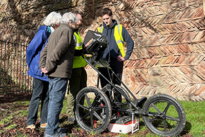
During February 2024 Archaeologist William Mitchell from Staffordshire University was once again in Tamworth leading a team of students and volunteers to conduct a geophysical investigation of the wider bailey area. These areas are known locally as The Dell (dip next to the herringbone wall) and the Lower and Upper Lawns (either side of the bandstand flowerbeds).
The public were also invited to visit the team to observe and learn more about the process and an archive research display was also showcased in Ankerside at the same time.
The surviving elements of Tamworth Castle were once part of a much larger fortification which was originally protected by a curtain wall and the river. During the medieval period, the lower castle bailey was accessed through a fortified gatehouse. This internal area would have been seen structures which supported the main castle, such as stables, storehouses and workshops.
During this geophysics investigation, a number of ground penetrating radar scans were undertaken on the lower castle bailey. The aim of this work is to provide data to research the likelihood of buried archaeological remains across the lawned areas of the castle’s lower bailey.
Ground Penetrating Radar is a well-established technique for the identification and investigation of buried remains. GPR functions by recording reflections of electromagnetic (radar) signals that are continuously emitted from a roving antenna, mounted on a cart. These reflections are affected by the physical properties of the subsurface and any buried features within it. These reflections are recorded, visualised and then analysed to determine the presence, size, and nature of any features buried beneath the ground surface. The survival and location of these can then be noted for future investigation.
What did we find?
The Ground Penetrating Radar (GPR) survey has been successful in characterising the below ground remains across Tamworth Castle Lower Bailey. Interpretation of the data has confirmed the presence of anomalies (including negative features and remains of a structural nature), at various locations within the landscape.
It is likely that buried remains exist in the location of buildings previously present on the site. The origins of these buildings and anomalies, some of which can be seen in the mapping from 1741 onwards, are unknown. Future invasive investigations may be able to determine a more detailed phasing of these likely features. There is a high probability that remains relating to the early phases of the castle’s construction remain buried, preserved beneath the topsoil, despite the numerous landscaping episodes which have occurred across the lower bailey.
Read the full GPR report here (pdf)
Historic England has granted a licence for this activity for the purposes of archaeological research and all projects have been funded from the UK Government through the UK Shared Prosperity Fund.